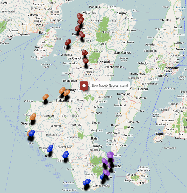
Slow Travel Map – Negros Island
Slow travel on Negros Island is not a style choice.
It is a practical reality shaped by the island’s geography, road network, and the way settlements are distributed between two long coastlines and a mountain spine running down the centre.
The island is 200 kilometres from north to south. Moving through it at any pace requires understanding how the coast roads work, where the inland loops branch off, which upland routes connect east to west, and where the natural pause points are — the towns, barangay clusters, river valleys, and coastal stretches where moving slowly is not only possible but the only way the place makes sense.
This map documents those routes and places across eight layers. Not itineraries. Not recommendations. The structure of movement as it actually exists on the island.
The Two Coasts
The coast roads of Negros Island are the primary slow travel routes on the island. Both coasts are accessible by road for most of their length, but they function differently and attract different kinds of movement.
The west coast — from Bacolod south through Talisay, Bago, Himamaylan, Kabankalan, Ilog, Cauayan, Hinoba-an, and Sipalay — is a sunset coast. The road faces west for most of its length and the light in the late afternoon on this side of the island is specific to it. The coastal stretches here are quieter than the east coast — less infrastructure, longer gaps between settlements, longer sections of road where the only thing alongside is the shoreline and small fishing barangays.
The Hinoba-an stretch is the longest continuous quiet coastal section on the west side — the coastal curve and sunset belt running through a municipality that sits far enough from both Kabankalan and Sipalay to feel remote from both. The Ilog coastal belt and the Kabankalan coastal curve are similar in character — the road following the shoreline through small barangay clusters without the resort infrastructure or dive tourism that marks the east coast south of Dumaguete.
Sipalay at the south of the west coast is different in character from the coast north of it. The coves belt here is a chain of small bays rather than a continuous shoreline, and the road moves in and out of visibility of the water. The sunset coast and coves belt in Sipalay are the most concentrated slow coast experience on the western side.
The east coast — from Guihulngan south through Sibulan, Dumaguete, Bacong, Dauin, Zamboanguita, and around to Basay, Bayawan, and Siaton — is a sunrise coast with more infrastructure, more movement, and a denser settlement pattern than the west. The east coast road is more travelled but no less suitable for slow movement if the timing and approach are right.
The Zamboanguita coastal belt and curve south of Dauin is the east coast’s quietest extended stretch — the road running through fishing barangay after fishing barangay without the resort cluster of Dauin or the city density of Dumaguete. Siaton’s coastal curve at the south is similar — long, quiet, shaped by small settlements rather than any single centre.
The north east coast — Guihulngan down through Amlan, San Jose, and Tanjay — is a fishing coast with a different character from the dive-coast stretch south of Dumaguete. The road here passes through barangays where the connection to the Tañon Strait is through fishing rather than tourism, and the rhythm is slower and less oriented toward outside visitors.
The far north coast — Sagay, Escalante, Cadiz, and Victorias — is the fishing coast of Negros Occidental, facing the Visayan Sea rather than the Tañon Strait. The Sagay coastal road is one of the longest quiet coastal drives in the province, running through barangays along the edge of the Sagay Marine Reserve with the sea on one side and the sugar belt on the other.
Village Pause Points
The village pause points on this map are the places along both coasts and in the interior where slowing down is most natural — where the settlement pattern, the daily rhythm, and the road character combine to make stopping feel like the right thing to do rather than an interruption.
The coastal village clusters are the most numerous — Sipalay’s fishing villages along the shoreline, the Zamboanguita coastal villages spread between the highway and the water, the Basay coastal villages at the south tip sitting between mountain and sea. These are not tourist villages. They are places where daily fishing life, drying zones, and barangay routine happen in sight of the road.
The inland village clusters are different in character — Ilog’s river villages spread along the valley, Kabankalan’s ridge villages on the inland side of the municipality, Cauayan’s inner villages connected by rural roads and farm tracks. These are accessible from the main road but one level removed from the coast and the highway traffic.
La Castellana’s sugar villages and Murcia’s sugar villages represent a third type — barangay clusters embedded in the agricultural landscape of the sugar belt, where the rhythm of life follows harvest rather than tide or market day.
Rural Loops and Backroads
The rural loops mapped here are the low-traffic inland roads that branch off the main coastal highways and connect farms, barangays, and small settlements in circuits that return to the main road without requiring a backtrack.
These are the routes that most road-based travel on Negros ignores because they add distance and time. That is also what makes them useful for slow travel — they pass through places the main road doesn’t, at a pace determined by road condition rather than traffic.
The Sipalay rural loop is the best example on the west coast — a circuit through inland farms and hill settlements behind the coves that gives a different perspective on the municipality than the coast road. The Ilog rural loop connects farming barangays in the river valley in a similar pattern. The Hinoba-an rural loop runs through upland villages east of the main road.
On the interior and east side: the Mabinay karst loop is the most distinctive — the road through Mabinay’s karst upland barangays passes through a landscape unlike anything else on the island, with limestone formations, cave entrances, and upland settlements that have no equivalent on the coast. The Bacong inner loop and rural loop represent the pattern at a small scale — local barangay roads running behind the coast highway through ordinary residential barangay life that the highway bypasses.
The Candoni upland loop on the far west interior is the most remote — a road through barangays that have limited connection to either coast and move at a pace determined by farming, distance, and terrain rather than any external rhythm.
Upland and Foothill Routes
The upland routes are the roads that climb away from the coastal plains toward the mountain zone — or in the case of the interior, the roads that move through the foothill belt between the plains and the mountain.
The Don Salvador Benedicto highland route is the most dramatic. The road climbs from the Negros Occidental sugar belt through a series of elevation changes into a cool mountain municipality where the air temperature, the crops, and the pace of life are all noticeably different from the coast or the plains below. This is a one-road-in situation — the route goes up and comes back down the same way unless you continue through to the trails and paths that connect to the interior forest zone.
The Canlaon foothill approach from the sugar belt passes through the transition zone between flat agricultural land and the mountain barangays at the base of the active volcano. The road here passes through foothill farming communities where the landscape shifts from sugarcane plains to mixed mountain farming over the course of a few kilometres.
The Valencia upland belt and highland pocket represent the east side equivalent — the climb from the Dumaguete coastal plain into the cool hills of Valencia, where the air changes and the landscape shifts to coffee, cacao, and upland vegetables. The Valencia waterfall approach extends further into the forest zone beyond the town.
The foothill belts in Sibulan, Bacong, Zamboanguita, Bayawan, and Siaton are the gentler version of the same transition — the edge where coastal movement begins rising toward the mountain interior. Each has a character specific to its position on the island.
River Valley Routes
The river valleys of Negros Island are the quietest inland routes. They are flat where the coasts are coastal and the uplands are elevated — the valley floor routes that follow water through the agricultural interior.
The Ilog river valley route is the most extended — the road following the river through the municipality’s agricultural plain, flanked by farms and connected to barangays along the valley sides. This is the inland alternative to the coast road in this section, and it moves at the pace of the landscape rather than the pace of traffic.
The Kabankalan river corridor connects the upland barangays to the town centre along the river — a route used by local residents daily that has a different character from the main road approach to the town. The Sibulan river corridor is similar in function — a local connection route along the valley that sits behind the coast road.
The Dumaguete riverside edge along the Banica River is the urban version of the same pattern — a quiet corridor through the city that sits away from the boulevard and the main commercial streets, where the pace slows in a way the waterfront frontage doesn’t allow.
The Mabinay river route through the karst uplands is the most unusual — river movement through a landscape where the watercourse has cut through limestone formations, creating a valley character specific to the karst zone of south Negros Oriental.
Town Wander Zones
The town wander zones are the parts of the island’s towns and cities where movement on foot is natural and where daily life is visible at walking pace.
Dumaguete has the most layered wander zones — the university grid where student movement, café clusters, and boarding house streets create a walkable daily rhythm distinct from the boulevard; the inner grid of residential streets that runs behind the commercial corridor; the backstreet loop of low-traffic lanes where the city’s quieter daily life happens; the market district where morning supply and trade rhythms begin; and the creative pocket of cafés and slow urban life around the university edges.
Bacolod’s wander zones are the heritage grid — the historic street layout of the city centre that predates the commercial development along Lacson Street — and the inner neighbourhoods of residential Bacolod that sit behind the commercial spine. These are not tourist zones. They are the parts of the city where the pace of daily life is visible without the overlay of commerce.
Valencia as a foothill town is the clearest example outside the two cities — a town centre with cafés, a market, cooler air, and a daily rhythm that differs from the coast in ways that are immediately noticeable. The town moves at a different pace from Dumaguete below it.
Silay’s heritage grid is a wander zone in a more literal sense — the ancestral house district is walkable, compact, and the streets themselves are the point rather than any specific destination within them.
La Carlota’s heritage pocket and Bacong’s heritage pocket are the smaller versions — older town cores where the civic buildings, church, and plaza layout reflect a different era of settlement than the highway-adjacent development that has grown around them.
Walking Routes
The walking routes are the specific corridors where movement on foot is established as a daily practice — not hiking trails, but the routes that local people actually use for walking as part of daily life.
The Dumaguete Boulevard Walk is the clearest example on the island — Rizal Boulevard is used every morning and evening by people walking for exercise, for routine, for the specific quality of light over the strait at those hours. It is a daily infrastructure in the same way the market is.
The Silay Heritage Walk is a walking circuit in a different sense — the ancestral house district is compact enough to cover on foot in an hour, and the experience of walking those streets is different from arriving by vehicle. The Silay Ancestral Pocket and the heritage grid are best understood at walking pace.
The Sipalay Coastal Walk along the coast road fronting the coves is the west coast equivalent of the boulevard walk — an evening walking route used by local residents that happens to run through the most scenic section of the municipality.
The Kabankalan River Walk and Zamboanguita Coastal Walk are the local versions in smaller municipalities — established daily walking routes that reflect how people in those towns actually move through the day.
Valencia’s ridge walk connects the town to the upland viewpoint looking back toward Dumaguete and the coast — a route that requires some effort but returns a view of the island’s geography that is unavailable from the road.
Heritage Areas
The heritage areas on this map are the zones where the built environment of an earlier period remains readable — where the architecture, street layout, and civic structures make the history of the place visible in the present.
Silay is the clearest heritage concentration on the island. The Silay Ancestral District and heritage grid together form the most intact collection of sugar-era ancestral houses in the Philippines. These are functioning family homes, not museums — the heritage character is embedded in daily life rather than separated from it. Walking through Silay is walking through a specific period of economic history that shaped the entire island.
The Talisay heritage pocket reflects the same era at a smaller scale — the sugar estates and heritage structures that exist in the shadow of nearby Bacolod and Silay, less visited but part of the same historical landscape.
La Carlota’s heritage core reflects the mill town character — civic and commercial buildings from the sugar processing era that give the town centre a different feel from the agricultural barangay towns around it.
The Dumaguete heritage corridor around the cathedral, Silliman, and the boulevard is the oldest walkable civic zone on the east coast. The institutions here — the university, the church, the waterfront civic space — were established in the early 20th century and their presence shapes the pace and character of that part of the city.
Bacong’s heritage pocket is smaller in scale — an older town core where the church and plaza layout predate the highway development and the pace of civic life reflects that earlier orientation.
How to Use This Map
The eight layers on this map can be used independently or together.
The coast routes show where coastal movement is most rewarding and least pressured by traffic. The village pause points show where stopping makes sense — where the settlement character justifies slowing down. The rural loops show which inland roads return to the highway without requiring a backtrack. The upland routes show where the mountain zone is accessible from the coast and what the approach looks like. The river valley routes show the quiet inland alternatives to the main road corridors. The town wander zones show which parts of the towns are worth moving through slowly on foot. The walking routes show where established foot movement already exists. The heritage areas show where built history is present at street level.
146 points are mapped across 8 layers covering both provinces and the interior.