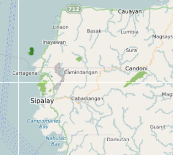
Sipalay – Cauayan Map (Town Orientation + Coastal Access)
Barangays (47)
Sipalay and Cauayan function through a string of coastal barangays rather than a single concentrated centre. The settlements are distributed along the coastal road from Cauayan in the north down through Sipalay’s barangay clusters and into the inland zones. Barangay halls and civic facilities are mapped across the system.
- Abaca, Basak, Bulata, Cabia-an, Caliling, Camalanda-an
- Camindangan — barangay hall and Sangguniang Pambarangay and Sangguniang Kabataan offices mapped
- Cauayan — the northern municipality, with its own barangay structure and civic centre
- Elihan, Gil Montilla, Guiljungan — barangay hall mapped
- Inayawan, Isio, Linaon, Lumbia, Mambusay, Man-uling
- Masaling, Molobolo, Nabulao, Nauhang, Poblacion
- San Jose, Sura, Talacdan, Tambad, Tiling, Tomina, Tuyom, Yaoyao
- Sipalay City Hall — main civic building
- Old Sipalay City Hall — heritage civic structure
- Cauayan Municipal Hall — Cauayan civic centre
- Guiljungan Barangay Hall — barangay-level governance
- Bahay Pamahalaan ng Barangay Camindangan — named barangay hall
Beaches & Water (390)
The most feature-dense layer on the map — 390 features covering the coastline, rivers, reefs, bays, islands, lagoons, and beach access points along the Sipalay–Cauayan corridor. The named water features below represent the key geographic anchors. Most of the 390 features are creek lines, river geometry, and coastal polygons that form the water geography of the area.
- Main beaches: Sugar Beach — the most visited stretch; Punta Ballo Beach — southern access; Turtle Beach, Tabon Beach, Typhoon Beach, Bugana Beach, East Beach, Poblacion Beach
- Bays: Campomanes Bay — the main bay framing the Sipalay coast; Nabulao Bay, Elihan Bay, Cartagena Bay, Punta Bulata Bay
- Islands: Agutayan Island, Anajauan Island — offshore islands accessible by boat from coastal barangays
- Lagoons: Malinab Lagoon, Moray Lagoon, North Lagoon, 4th Lagoon, Huyop Huyop, Tinagong Dagat — inland lake accessible from San Carlos direction
- Dive reefs: Andres Reef, Manta Reef, Tanguigue Reef, Guadalupe Reef (in schema), Convention Reef, Bonifacio Reef, Hillary’s Reef, Wilson’s Reef, North Wall, Reef Area
- Rivers: Bagambang River, Cauayan River, Dapdap River, Dautan River, Guiljungan River, Isio River, Mabua River, Maricalum River, Omiles Creek, Tabangan River, Tablas Valley River, Taongan River, Tiling River, Binulug Creek, Cansibit Lake
- Beach resorts on coast: Artistic Diving Beach Resort and Dive Center, Bermuda Beach Resort, Buenaventura Beach Resort, CampoQuino Bay Beach Resort, Easy Diving and Beach Resort, Langub Videoke Beach Resort, Nataasan Beach Resort and Dive Center, Punta Bulata Beach Resort, Robinson Cruse Beach Resort, Takatuka Beach Resort, Tylers Beach House
- Island hopping: Sipalay Island Hopping — named departure and activity point
Culture & Landmarks (27)
The culture layer covers religious buildings, heritage sites, and civic landmarks across Sipalay and Cauayan. Parish Of St. Paul the Apostle is the main Catholic church for Sipalay. San Fabian Catholic Church serves Cauayan. The Maricalum Mining Corporation Ruins reflect the area’s industrial history — the remains of the copper mining operation that shaped Sipalay’s development in the twentieth century.
- Parish Of St. Paul The Apostle — main Catholic church, Sipalay
- San Fabian Catholic Church — Cauayan
- Señor Santo Niño Chapel — local chapel
- Cansauro Baptist Church — Protestant congregation
- Iglesia Ni Cristo — multiple locales across the barangays
- Lokal ng Luyang — Iglesia ni Cristo locale, Luyang barangay
- 7th Day Adventist — church, barangay zone
- The Church of Jesus Christ of Latter-day Saints
- Maricalum Mining Corporation Ruins — former copper mine, industrial heritage landmark
- Maricalom Fish Sanctuary — protected marine area on the coast
- Papa Isio — historical reference marker for the revolutionary leader associated with the Negros uprising
- Public Artwork — named installation on the map
Activities (24)
Activities in Sipalay and Cauayan are predominantly water-based — diving, snorkelling, island hopping, and reef access from the coastal barangays. Inland activities connect to the ridge and upland terrain behind the coast. The named dive sites in the Beaches & Water layer are the primary diving reference points; the Activities layer covers operator locations, camp and ridge access, and sports facilities.
- Sipalay Island Hopping — organised boat trips to offshore islands from the coastal barangays
- Dive Shop — dive equipment and operator base on the coast
- Doug’s Ridge — ridge trail access point in the upland barangays
- Eagle’s Nest — elevated viewpoint or ridge camp location
- Ridge — trail access to the upland terrain
- Camp Site — designated overnight camping location
- Picnic Area — designated leisure area, coastal or inland
- Playground — barangay-level recreation area
- Sports Centre — sports facility in the town area
Cafés & Food Areas (17)
Food options in Sipalay and Cauayan are distributed across the beach resort strip, the Sipalay town centre, and a smaller cluster in Cauayan. The resort-based restaurants serve primarily their own guests. The town centre options — canteens, local cafes, and small restaurants — are what the local population and non-resort visitors use. Cooked food from town-centre canteens is typically available until early afternoon.
- Abaca Cafe — named cafe in the area
- Acuaria — cafe or restaurant
- Cafe El Paso — Western-menu cafe in the town area
- Carag’s Cafe — local cafe
- GROOGIES’ Soup and Grill — grill and soup restaurant
- Nudibranch — dive-adjacent cafe or restaurant, named for the local marine life
- San Vicente Finest Bread — local bakery
- Snack Haus — snack and light meal spot
- Sugar Rocks Music Bar — bar with food in the beach area
- Wouda Resto — local restaurant
- Local Café, Local Restaurant, KyLa’s, Ludz, Senior, Canteen — town centre eating options
Local Life (43)
The local life layer maps the everyday infrastructure of Sipalay and Cauayan — purok subdivisions within barangays, repair shops, rice trading, local services, health facilities, and the viewpoints and civic structures that are part of daily movement rather than tourism. The Cauayan Rural Health Unit and the Sipalay and Cauayan civic halls are the main public service anchors.
- Cauayan Rural Health Unit — public health facility
- Bacolod-Sipalay — road route reference and distance marker
- Sunset View Deck — public viewing deck
- Viewpoint — public elevated view
- Taytay sa Kauswagan — named civic or community structure
- Tower — communications or civic tower
- Visitor Information — information point
- Purok 1, Purok 2, Purok 3, Purok 5, Purok Mangga — purok subdivisions within barangays
- Du Ek Sam — local business
- JTR Cycle Parts Center — bicycle parts and repair
- Repair Shop — general repair
- Rice grane — rice trading or storage
- Butcher — local meat supply point
- Wetland, Cabugan, Luyang, Mabua, Negros — geographic reference points
- Learning Center, Public Artwork, North Wall — community and civic markers
Markets & Shopping (34)
Markets in Sipalay and Cauayan are small by provincial standards — both towns have their own public market, with the Cauayan Public Market and the Sipalay Public Market (Wet Market) serving as the main daily supply points for fresh produce, fish, and dry goods. Convenience stores and small shops are distributed through the coastal barangays.
- Cauayan Public Market — main market for Cauayan municipality
- Gulijungan Public Market — barangay-level market in Guiljungan
- Public Market — Sipalay town centre market
- Wet Market — wet goods market, town centre
- Jiga Enterprises — local supplier or store
- Nig Marketing — local trading
- Convenience Store — general convenience retail
Nature & Waterfalls (19)
The inland terrain behind Sipalay and Cauayan rises sharply from the coastal strip into a series of mountains and ridges. Most of these are not commonly visited and have no formal trail infrastructure — access is by habal-habal from the coastal barangays and requires local knowledge. The Bat Cave is the most accessible named natural feature from the coastal road.
- Bat Cave — accessible cave from the coastal road, barangay area
- Mount Hinologan Calis — named mountain in the upland zone
- Mount Malapantao — upland mountain
- Mount Tantauayan — upland mountain
- Cabadiangan Mountain, Calangcang Mountain, Calatong Mountain, Canturay Mountain, Panlubongan Mountain — named peaks in the interior
- Capaclan Hill, Dapdap Hill, Twin Peaks — lesser hills in the inland zone
- Cave Entrance — named cave access point
- Nature Reserve — protected area in the inland barangays
- Sipalay City Park — town-level park
- Woodland — forested area in the upland barangays
Stay Local (33)
Accommodation in Sipalay and Cauayan divides between the beach resort strip — where resorts operate along the shoreline from Punta Ballo through Campomanes Bay and up toward Punta Bulata — and the town-centre pension houses and small lodges in Sipalay and Cauayan proper. The beach resorts control access to the best coastal sections. Town-centre options are cheaper and used by people in transit or on work trips.
- Beach resorts: Big Bam Boo Resort, Takatuka Beach Resort, Driftwood Village Resort, Easy Diving and Beach Resort, Nataasan Beach Resort and Dive Center, Artistic Diving Beach Resort and Dive Center, Punta Bulata Beach Resort, Bermuda Beach Resort, Buenaventura Beach Resort, CampoQuino Bay Beach Resort, Robinson Cruse Beach Resort, Sulu Sunset Resort, Develdos Resort, Didai’s Garden Resort, Green Garden Resort, Tawhay Resort, Langub Videoke Beach Resort
- Town centre and pension houses: Sipalay Suites, Perth Resort, Eva’s Inn, Francis Lodge, BANGGA ANGEL VICTORIA LODGING HOUSE, C View Haven, Matlag Farm House, tourist lodging center, Chalet Stay
- Private and long-stay: Lory Tanjusay’s Residence, Romeo Tanjusay’s Residence, Joseph Cases, Tylers Beach House
Services (5)
The services layer is small — Sipalay and Cauayan are not major service centres by Negros Occidental standards. For specialist healthcare and a wider range of banking and government services, Kabankalan is the nearest larger centre to the north.
- Merciditas M. Montilla District Hospital — main public hospital for Sipalay
- Cauayan District Hospital — public hospital for Cauayan
- Cauayan Police Station — Cauayan municipal police
- Central Philippines State University – Sipalay Campus
- Central Philippines State University – Cauayan Campus
- Cabarrus Catholic College — private college
- Rural Bank of Ilog, Inc. — local rural bank
- PhlPost — Philippine Postal Corporation office
Transport (14)
Movement along the Sipalay–Cauayan corridor follows the coastal road that links all the barangays from Cauayan in the north to Sipalay and down toward Basay at the island’s southern tip. The Ceres bus terminal in Sipalay is the departure point for services north toward Kabankalan and Bacolod. Bridges along the route are mapped as the key crossing points on the coastal road.
- Ceres Terminal in 2025 — Sipalay Ceres bus terminal, northbound services
- Sipalay Airport — limited domestic services, grass airstrip
- Ferry Terminal — coastal ferry connection point
- Petron Gas Station, Fuel Station — fuel points along the coastal road
- HIGH V — fuel station
- Bridges along the coastal road: Bagambang Bridge, Balangay Bridge, Camindangan Bridge, Cauayan Bridge, Dautan Bridge, Guiljungan Bridge, Isio Bridge, Mabua Bridge, Magambac Bridge, Talagpun-ay Bridge, Tiling Bridge, Tinabunan Bridge
Warnings & Seasonal Risks (9)
The Sipalay–Cauayan coast faces the Sulu Sea and is exposed to weather systems from the south-west. The southwest monsoon (June–October) brings consistent rain and can make some coastal roads impassable and sea conditions unsuitable for island hopping and reef access. The inland mountain roads to the upland barangays deteriorate significantly after heavy rain.
- Coastal road flooding — low-lying sections between barangays flood during heavy monsoon rain
- Island hopping and reef access — suspended or unsafe during southwest monsoon, particularly July–September
- Mountain road conditions — habal-habal routes to the inland barangays and upland terrain become hazardous in wet season
- River crossings — bridges including Cauayan Bridge and Camindangan Bridge are monitored during heavy rain events
- Beach resort access — some beach resort roads become muddy and difficult for non-4WD vehicles after sustained rain
- Dive conditions — reef access and visibility affected by seasonal weather and occasional strong current periods
Sipalay – Cauayan Map
Sipalay and Cauayan sit along the south-west coast of Negros Occidental where the island’s main highway gives way to a narrower coastal road running through barangays rather than towns. The two municipalities are often treated as a single destination, and on the ground they function as one connected coastal system — settlements, beaches, reefs, and inland terrain all linked along the same route.
This map covers both municipalities in full: the coastal barangay corridor, beach and island access points, dive sites, accommodation, markets, services, and the inland upland areas behind the coast.
How the Coastal System Works
The coastal road is the spine of movement through the area. It runs north from Sipalay through Cauayan and continues toward Kabankalan and eventually Bacolod — a journey of around four hours by Ceres bus to the provincial capital. In the other direction, the road south from Sipalay follows the coast through Basay toward the island’s southern tip.
The barangays are not uniformly distributed along this road. Some — Gil Montilla, Nauhang, Bulata, Linaon — sit on or very close to the shore. Others are further inland, connected by barangay roads that branch off the coastal route. The settlement pattern is loose rather than concentrated, which means knowing which barangay a place is in matters for navigation more than it does in a conventional town.
Campomanes Bay is the largest geographic feature of the Sipalay coast — a substantial sheltered bay framing the main stretch of beach and reef activity. The bay’s shape determines where boat routes go, where reefs are accessible, and where the best beach access sits. Punta Ballo is the southern headland of the bay. Sugar Beach is on the northern side, accessed from the Gil Montilla barangay road.
Cauayan sits north of Sipalay and has its own civic centre, public market, hospital, and barangay structure. Movement between Sipalay and Cauayan is by the coastal road — approximately 25 kilometres.
Beaches and Coastal Access
Beach access in Sipalay is not uniform. The main resort beaches — Sugar Beach, Punta Ballo — are reached by barangay roads off the coastal highway and in some cases require a boat transfer from a drop-off point. The resort infrastructure along these stretches controls access to the best sections of shore.
Public beach access exists through the barangay zones, but the easiest shoreline to reach without a resort booking is the Poblacion Beach area near the town centre and the sections of coast visible from the coastal road through the fishing barangays.
Offshore, Agutayan Island and Anajauan Island are accessible by boat from coastal departure points. Island hopping — organised by operators based near the resort strip — covers these islands and several of the reef areas. The 4th Lagoon, Malinab Lagoon, Moray Lagoon, Huyop Huyop, and North Lagoon are enclosed or semi-enclosed water bodies along the coast accessible by boat.
Dive Sites and Reefs
The reef system around Sipalay is distributed across the bay and along the outer coast. Andres Reef, Manta Reef, Tanguigue Reef, Convention Reef, Bonifacio Reef, Hillary’s Reef, and Wilson’s Reef are the main named sites. Most are accessed by banca from the resort strip. Conditions and visibility vary with season — the southwest monsoon from June to October brings choppy conditions and reduced visibility.
Dive operators based in the area include Easy Diving and Beach Resort, Nataasan Beach Resort and Dive Center, and Artistic Diving Beach Resort and Dive Center. Most cater primarily to resort guests. Independent divers can arrange trips through the operators directly.
The Maricalom Fish Sanctuary is a protected marine area on the coast, established to protect reef biodiversity. Entry into the sanctuary zone requires adherence to local conservation rules.
Accommodation
The accommodation split is clear. Beach resorts line the Campomanes Bay shoreline and the approaches to Sugar Beach and Punta Ballo — Big Bam Boo Resort, Takatuka Beach Resort, Driftwood Village Resort, Punta Bulata White Beach Resort, Easy Diving and Beach Resort, Nataasan Beach Resort, and a number of smaller beach operations. These resorts control the best coastal access and set the price point for beachside stays.
In the town centres, pension houses and small lodges operate at a lower price point and without direct beach access. Sipalay Suites, Perth Resort, Eva’s Inn, and several family-run pension houses are in this category. These are used mainly by people in transit, workers, and visitors who prefer to be near the market and transport rather than on the resort strip.
Markets and Services
Sipalay has a public wet market in the town centre — the main daily supply point for produce, fish, and dry goods. The Cauayan Public Market serves the same function for the northern municipality. Guiljungan has a smaller market at barangay level.
For services, both municipalities have district hospitals: Merciditas M. Montilla District Hospital in Sipalay and Cauayan District Hospital. Both have Central Philippines State University campuses — Sipalay Campus and Cauayan Campus. The Rural Bank of Ilog and PhlPost operate in the area.
For larger banking, more specialist healthcare, or a wider range of commercial services, Kabankalan is the nearest larger centre to the north.
Inland and Upland Areas
Behind the coastal strip the terrain rises quickly into a series of mountains and ridges. Mount Hinologan Calis, Mount Malapantao, Mount Tantauayan, Cabadiangan Mountain, Calangcang Mountain, Canturay Mountain, and Panlubongan Mountain are all marked on the map. Access to the mountain barangays is by habal-habal from the coastal road. No formal trail infrastructure exists for most of these peaks, and access requires local knowledge.
The Bat Cave is the most accessible natural feature from the coastal road. Doug’s Ridge and Eagle’s Nest are informal access points to the elevated terrain used by local hikers. Tinagong Dagat — a lake accessible from the San Carlos direction to the north — sits in the interior behind the Cauayan zone.
Transport
The Ceres bus terminal in Sipalay is the departure point for northbound services toward Kabankalan and Bacolod. The journey to Bacolod takes approximately four hours. There is no direct Ceres service running the full length of the coast in one go from the south tip — passengers travelling from Basay connect at Sipalay.
Sipalay Airport has a grass airstrip and limited domestic services — check current schedules directly as these vary.
Twelve bridges along the coastal road are mapped — from Bagambang Bridge in the north through to Tinabunan Bridge further south. These crossing points are the places where the road is most vulnerable during heavy monsoon rain.
How It Actually Works
The Sipalay–Cauayan system is not organised around a single town centre. It functions as a corridor where beaches, reefs, barangay centres, markets, and services are distributed along a coastal road rather than clustered in one place. Understanding where each part of the system is — which beach is in which barangay, which road leads where, how far apart the two municipality centres are — is what allows movement through it to work without confusion.
Movement is by coastal road for the main corridor. Island and reef access is by banca. Upland barangay access is by habal-habal. The Ceres bus is the connection north to the rest of the island.
Related Guides
- The Insider’s Slow Map of Negros — the full map series index for Negros Island
- Negros Beaches Map — coastal access points across both provinces
- Slow Travel Map – Negros Island — how transport and movement works across the island
- Getting Around Negros Island the Slow Way — transport options and how the Ceres network connects