
Silay Map (Heritage Core + Practical Stops)
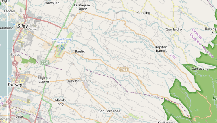
Barangays (65)
Silay has 27 barangays spread from the heritage town centre to the agricultural areas east toward the foothills and north and south along the coastal plain. The numbered barangays (I–V and their subdivisions) are in the poblacion. The named barangays cover the surrounding agricultural and coastal zones. Barangay halls — Bahay Pamahalaan — are marked across the map.
- Barangay I, Barangay II, Barangay III, Barangay IV, Barangay V — poblacion numbered barangays
- Balaring — coastal barangay north of the town centre
- Guinhalaran — barangay south of town, along the coastal highway
- Patag — upland barangay toward the foothills
- Bagtic — agricultural barangay with hacienda areas
- Lantad — barangay with trail access to the upland zone
- Mambulac — barangay with river access and coastal position
- Guimbala-on — agricultural barangay
- Kapitan Ramos, Eustaquio Lopez, Rizal — named agricultural barangays
- Hawaiian — barangay near the coastal strip
- Bahay Pamahalaan ng Barangay Eustaquio Lopez, Guinhalaran, I, III, V — barangay halls mapped
Beaches & Water (435)
The water layer is the most feature-dense on the map — 435 features covering rivers, creeks, coastal areas, mangrove zones, and freshwater bodies across Silay’s barangays. Most features are creek and river geometry rather than named swimming beaches. The Balaring mangrove area on the coast is the main accessible natural water feature. Silay’s coast faces the Guimaras Strait.
- Balaring Mangrove Eco-tourism Park — mangrove forest with boardwalk, coastal Balaring barangay
- Balaring Mangrove Tower — observation tower within the mangrove park
- Cabug Baybay — coastal shoreline area, Cabug barangay
- McKinley Baybay — coastal shoreline area
- Lake Aurora — inland water body
- Pulang Tubig — named red water spring, upland zone
- Cuyong River, Guinhalaran River, Hinalinan River, Malisbog River — major named rivers
- Malogo River, Mambag-id River, Napilas River, Nasacub River, Small Napilas River
- Baao Creek, Bagacay Creek, Bucay Creek, Cabaynan Creek, Cabug Creek
- Comabal Creek, Macanig Creek, Malinao Creek, Matagoy Creek, Muyao Creek
- Cubay, Dumalabdab Falls — water features in upland barangays
- Bagacay Bridge, Cabug Bridge, Guinhalaran Bridge, Matagoy Bridge 1 — river crossing points
Culture & Landmarks (39)
Silay’s heritage district contains one of the highest concentrations of ancestral houses in the Philippines. Most are privately owned — visible from the street, with a small number operating as museums, accommodation, or events venues. The San Diego Pro-Cathedral and Balay Negrense Museum anchor the public cultural sites. Heritage markers from NHCP are placed on several houses that are not open to the public.
- Museums: Balay Negrense Museum, Don Bernardino Jalandoni Museum, Manuel Severino Hofileña House
- Ancestral houses: Angel Araneta Ledesma House, Benita Jara House, Vicente Conlu Montelibano Ancestral House, Jose “Pitong” Ledesma Ancestral House, Kapitan Marciano Montelibano Lacson House, German Lacson Gaston Ancestral House, German Locsin Unson Ancestral House, Manuel de la Rama Locsin Ancestral House, Generoso Reyes Gamboa Ancestral House
- Historical markers: Cinco de Noviembre Marker — site of 1898 revolution against Spain; German Locsin Unson Ancestral House historical marker; Manuel Severino Hofileña House historical marker
- Churches: San Diego Pro-Cathedral — main Catholic church; Buenavista Chapel; Virgen Sang Barangay National Shrine; Domus Dei
- Iglesia ni Cristo: Lokal ng Silay, Lokal ng Lantad, Iglesia ni Cristo Guimbala-on GWS
- Other: Old Silay Wharf — heritage waterfront structure; Diwal Platform — elevated viewpoint; Cato village; Newsite; Vantage
Activities (4)
The activities layer maps the main recreational areas around Silay — the Lantawan Trail system into the Northern Negros Natural Park, the Danao Crater in the upland barangays, and the golf course in the airport zone. Access to the upland activities requires a habal-habal from the poblacion.
- Lantawan Trail — trail system leading into the Northern Negros Natural Park from Silay’s upland barangays; trail entrance marked in the Services layer
- Danao Crater — volcanic crater in the upland barangay zone
- Golf — golf course in the airport corridor area
- Northern Negros Natural Park — protected forest park covering the upper elevations of Silay and surrounding municipalities
Cafés & Food Areas (47)
Silay’s food scene is split between the heritage district cafes and restaurants concentrated in the town centre, the roadside and airport-adjacent food options along the Bacolod-Cadiz highway, and the coastal barangay dining. The town is known for El Ideal — a long-running bakery and cafe in the heritage area — and for the heritage house restaurants that have converted part of their space to food service.
- Heritage district: El Ideal — long-established bakery and cafe; 1898 — inside a heritage building; Cafe 1925; Stephen’s at Balay Puti; Cocina de Barrio; Emma Lacson; La Rosa
- Cafes: Balay Kapehan, Balay Silaynon, Cafe Velo, Café Katartizo, Duyan Cafe, Expresso Cafe, Feel Us Cafe, Kapihan sa Kilid Dalan, Kuppa, Lantawan Native Coffee, Liway Cafe, Pantaw Cafe, Rooster Cafe, Sky Go Cafe & Resto, Hestia’s, Larga, B+C, SIR
- Restaurants: Edgewater Native Restaurant, Fishers Pond Seafood and Grill, Melkens Seafood Restaurant, Seaside Floating Restaurant, Ann Co Cakes, KKD Pizzaria
- Fast food chains: Jollibee, McDonald’s, Mang Inasal, Dunkin’ Donuts
- Airport corridor food: Airport COOP Canteen, BAMCI Airport Canteen, M/V Felicious Cafe, Pares ni Peso, Golden Food Park
- Local food: Chicken House — inasal, Silay branch; Merzci — pasalubong and local sweets
Local Life (49)
The local life layer maps the daily infrastructure of Silay — the points of routine movement, civic activity, and barangay-level service. Silay functions at two speeds: the town centre and highway corridor that connects to Bacolod, and the quieter agricultural barangays where daily life follows farm and hacienda rhythms.
- Barangay halls — marked across all major barangays: Bagtic Barangay Hall, Barangay II Hall, Barangay IV Hall, Rizal Barangay Hall
- Silay City Plaza — civic square in the town centre
- Silay Public Market — the main daily market, central to town rhythm
- Bebing Alunan Store Public Market — neighbourhood market
- Hacienda areas — Hda. Cilisap 1, Hda. Calbario brgy. Bagtic — the agricultural hacienda landscape visible from the roads
- Saint Francis Executive Village — residential subdivision
- Newsite, Poblacion — district references within the town
- Jeepney routes — Silay town to Bacolod marked along Rizal Street with northbound and southbound stops
Markets & Shopping (36)
The markets layer covers the public market, supermarkets, general stores, and retail spread across Silay. Shopping is concentrated near the town centre and along the Bacolod-Cadiz highway. The Gaisano Grand Mall Silay is the main commercial centre. SM Savemore and Lopues Silay cover supermarket needs. Local stores and sari-sari stores serve the barangay zones.
- Main market: Silay Public Market — daily wet market, town centre
- Supermarkets & malls: Gaisano Grand Mall Silay, Gaisano Grand Silay Supermarket, SM Savemore, Lopues Silay, Prince Hypermart, Novo
- Pasalubong & local products: Merzci — local brand; Bong-bong’s — local sweets chain; Islands Souvenirs; Duty Free Philippines — airport terminal
- Convenience: 7-Eleven, Emperador
- General stores: Asher Allied Marketing, Benjie Store, Demogena Store, Emmalinda Delima Store, Emman Store, JTK Store, Keithlyn’s Store, Silario’s
- Retail: Penshoppe, Deocampo Tailoring, Prestige Eyecare, Thelm’s Beauty Parlor, Yasmin, The Blade
- Gas & supplies: Prycegas — LPG delivery
Nature & Waterfalls (10)
Silay’s natural areas are concentrated in the upland barangays east of the town toward the foothills of the Northern Negros Natural Park. The Lantawan Trail is the main access route into the upland zone. Pulang Tubig — the red spring — is a named freshwater feature in the upland barangays. Access to most natural sites requires a habal-habal from the town centre and is affected by seasonal conditions.
- Northern Negros Natural Park — protected forest covering upper elevations of Silay and surrounding municipalities
- Marapara Peak — mountain peak visible from the town and coastal plain
- Pine Tree Peak — secondary peak in the upland barangay zone
- St. Francis Nature Park — nature park with trail access
- Pulang Tubig Waterfall Trail — trail to the red water spring and associated falls
- Pulang Tubig — the red spring itself, named for its iron-rich water
- Danao Crater — volcanic crater, upland barangay access
- Cacao Top — elevated point in the upland barangays
- Lantawan — upland access point and trail junction
- Silay City Plaza — the main public green space in the town centre
Stay Local (24)
Accommodation in Silay is spread between the heritage district — where several ancestral houses operate as bed and breakfasts or heritage stays — and the highway corridor pension houses serving travellers between Bacolod and the north. The hacienda stays in the agricultural barangays are the most distinctive options, sitting within working farm or heritage estate properties.
- Heritage stays: 1898 — inside a heritage building in the town centre; German Unson Heritage House Bed & Breakfast — ancestral house accommodation; Stephen’s at Balay Puti — heritage house with accommodation
- Hacienda stays: GK Hacienda Paz, Hacienda La Purisima, Hacienda Paz Matagoy, Hacienda Santa Isabel, GK Fiat Silay — estate-based accommodation in the agricultural barangays
- Pension houses: Baldevia Pension House, Pegasus Pension, Richmond Inn — town centre and highway corridor options
- Other: Hawaiian — accommodation in the coastal barangay; Sion residence
Services (37)
Silay carries the main services for the towns along the north coast corridor — banks, the provincial hospital, schools, and government offices. Most services are concentrated in the town centre and along Rizal Street. For specialist healthcare and a wider range of banking, Bacolod is 15 kilometres south.
- Government: Silay City Hall, Silay Police Station, Silay Fire Station, Fire Station Building
- Hospital: Teresita L. Jalandoni Provincial Hospital — the main public hospital for Silay and the surrounding municipalities
- Pharmacies: Mercury Drug, Negros Grace Pharmacy
- Banks: BDO, BPI, Metrobank, LandBank, PNB — Philippine National Bank, EastWest Unibank
- Education: Silay Institute — private school with long heritage in the town; Aeronav Academy — aviation training near the airport
- Trail access: Lantawan Trail Entrance — the marked entry point for the upland trail system
- Other: Multiple Use Boundary — land classification marker for the Northern Negros Natural Park edge
Transport (47)
Silay is where Bacolod-Silay International Airport sits — the main entry point for Negros Occidental by air. The airport is 15 kilometres from Bacolod city centre and effectively functions as Bacolod’s airport. Silay town is connected to Bacolod by jeepney along Rizal Street. Northbound Ceres buses pass through on the highway toward Cadiz and San Carlos. Fuel stations are distributed along the highway corridor.
- Airport: Bacolod-Silay International Airport Terminal — main passenger terminal; Cargo Terminal — cargo handling facility; Bacolod Airport Carpark; Airport COOP Canteen, BAMCI Airport Canteen — airport-adjacent food; Duty Free Philippines — departure area; Aeronav Academy — aviation training
- Jeepney route: Jeepney to Bacolod — departs from the town centre; stops mapped along Rizal Street at Buenavista Subd., Carmela, Doña Montserrat, Gaisano Silay, Guinhalaran, Oxy, PNB Silay, Silay Market, Teresita Jalandoni Hospital — northbound and southbound stops documented
- Fuel stations: Petron, Shell, Caltex, Phoenix, Seaoil, Petro Gazz, Total — distributed along the highway; 3MR — local station
Warnings & Seasonal Risks (16)
The warnings layer marks areas and conditions that affect movement and access in Silay at certain times of year. Creek flooding during the southwest monsoon (June–October) affects low-lying barangays along the river corridors. The upland trail to Lantawan and the natural park is affected by rainfall — conditions deteriorate quickly after heavy rain. Some coastal areas experience tidal flooding during storm surges.
- Creek flood zones — low-lying areas along Cabug Creek, Macanig Creek, and the Guinhalaran River corridor
- Upland trail conditions — Lantawan Trail and Northern Negros Natural Park access affected by heavy rain; trail surface becomes slippery and some creek crossings become hazardous
- Coastal flooding risk — Balaring and Mambulac coastal barangays at risk during storm surges
- Road hazard points — sharp curves and narrow bridges mapped along the barangay roads: Before Diwal Wall, sharp curve markers on upland routes
- Bridge crossing alerts — Bagacay Bridge, Cabug Bridge, Guinhalaran Bridge, Matagoy Bridge — monitored during heavy rain events
- Seasonal access — some barangay roads toward Patag and Lantad are unpaved and become difficult in wet season for standard vehicles; habal-habal access remains but with caution
Silay Map – Negros Occidental
Silay sits fifteen kilometres north of Bacolod along the coastal highway. It has its own city hall, its own public market, its own barangay structure — but for most people passing through on the Ceres bus, it registers as a stop between the airport and Bacolod rather than a place to stay or spend time. The map covers what is actually there: the heritage zone in the old town centre, the barangays spreading east into former hacienda land, the coastal fringe of aquaculture ponds and mangroves, and the upland areas that push toward the Northern Negros Natural Park and Marapara Peak.
The Barangay Structure
Silay divides into barangays that sit across a significant geographic range. The coastal and town barangays — Barangay I, II, III, and IV — make up the poblacion zone and carry the heritage designation. Barangay I and III are specifically noted in OSM data as the Silay Heritage Zone. These are the barangays where the ancestral houses are concentrated, where the San Diego Pro-Cathedral stands, and where the daily market and commercial activity happen.
Moving east, the barangays shift in character. Guinhalaran sits south of the town centre toward the boundary with Talisay. Mambulac and Lantad are to the east, where the land was historically organised around haciendas — sugar estates that divided the interior into named parcels. Balaring is in the northwest, along the coast. Hawaiian is further north, named for the sugar company that operated there. Kapitan Ramos and Eustaquio Lopez are among the outer barangays, further into what is now a mix of agricultural and residential land. Bagtic and Patag extend into the eastern uplands, where the terrain rises toward the mountain range.
The sitios and puroks within these barangays carry hacienda names — Hacienda La Purisima, Hacienda Santa Isabel, Benita Jarra — which remain in use as local reference points even where the agricultural operations they referred to have changed.
The Heritage Zone
The old town centre of Silay holds the densest concentration of ancestral houses remaining in Negros Occidental. These are the houses built by sugar families during the industry’s peak, most of them from the late nineteenth century through the 1920s. Several are mapped:
The Balay Negrense Museum is the most formally developed — a restored ancestral house open as a museum, documenting domestic life from the sugar era. The Don Bernardino Jalandoni Museum, the Manuel Severino Hofileña House, the Angel Araneta Ledesma House, and the Benita Jara House are also mapped as museums or historic buildings. The German Locsin Unson and German Lacson Gaston ancestral houses appear in the data as historic memorials, along with several others.
The heritage markers in the data include the Cinco de Noviembre Marker — a reference to the date of a local uprising in 1898 — and the old Silay wharf, which is mapped as a tourism attraction and marks where coastal trade entered the town before the highway era.
The San Diego Pro-Cathedral is the main church. The Virgen Sang Barangay National Shrine is a separate place of worship within the heritage zone.
The Airport Corridor
Bacolod-Silay International Airport sits within Silay’s territory, in Barangay II on the eastern edge of the poblacion zone. The airport terminal and cargo terminal are both mapped. The airport carpark occupies a significant footprint along the access road.
The airport’s presence shapes the area around it. The jeepney service to Bacolod operates from near the airport, connecting arriving passengers to the city. The fuel stations, the convenience stores, and the fast food outlets along the main road near the airport — Jollibee, McDonald’s, Mang Inasal — serve both transit traffic and local daily movement.
Duty Free Philippines and Islands Souvenirs are mapped near the airport approach, reflecting the transit function of this part of the highway corridor.
The Town Centre
The commercial area of Silay is compact. The Silay Public Market is the main food and goods market, located centrally in the heritage zone. Lopues Silay, Gaisano Grand Mall, and SM Savemore provide the supermarket and department store layer that most Negrense towns have in some form.
Cafes are notably concentrated in Silay relative to its size. Cafe 1925, Balay Kapehan, Duyan Cafe, La Rosa, Lantawan Native Coffee, and more than a dozen others are mapped in and around the heritage zone. This reflects both the heritage tourism pull and the town’s character as a place where people stop and sit rather than pass through at speed.
Restaurants include Balay Silaynon, Stephen’s at Balay Puti, Seaside Floating Restaurant, Melkens Seafood Restaurant, and the Golden Food Park. The fast food layer — El Ideal alongside the national chains — fills out the daily food zone.
Banking is well represented: BDO, BPI, LandBank, Metrobank, Philippine National Bank, and EastWest are all mapped, with ATMs across the town centre.
The Coast
The western edge of Silay faces the Guimaras Strait, but the coastline here is not a beach coast. Aquaculture ponds — 121 mapped in the data — cover the coastal plain between the town and the water. The Balaring Mangrove Eco-tourism Park occupies the northwestern coastal zone, managed as a nature reserve with a mangrove tower viewpoint. The wetland areas along this stretch are ecologically significant but not accessible in the way beaches further south are.
The Old Silay Wharf is the main coastal reference point with historical relevance. The Seaside Floating Restaurant sits on or near the water further south, in the area where the coast becomes accessible from the town roads.
The Uplands and Trail Access
East of the town, the terrain rises toward the Northern Negros Natural Park, which sits within Silay’s administrative territory. Marapara Peak is the named summit — mapped with a second unnamed peak nearby. Danao Crater is recorded as a natural cliff feature in this zone.
The Lantawan Trail is the main documented access route into the uplands. Trail entry is mapped at the Lantawan Trail Entrance, and a series of campsites run along the trail: Agsam 1, Agsam 2, Agsam 3, Pine Tree Peak, Platform 2, Diwal Platform, and others. The Pulang Tubig Waterfall Trail branches from this zone. Viewpoints at Vantage and Diwal Platform are mapped, with the Balaring Mangrove Tower serving a different viewpoint function at the coast.
The sitio of Tayap and the village of Hiyang-hiyang are in Patag barangay in the eastern uplands, accessible by road from the town but at some distance from the heritage and airport zone.
Accommodation
Accommodation in Silay is small in scale. Richmond Inn is the one mapped hotel. Guesthouses include GK Fiat Silay, GK Hacienda Paz, Baldevia Pension House, Pegasus Pension, and the German Unson Heritage House Bed and Breakfast — the last one operating from within the heritage zone itself. 1898 appears both as a guesthouse and a restaurant. Four apartments are mapped in the Patag area, east of the main town.
Getting There and Moving Around
Ceres buses running the Bacolod–Cadiz route pass through Silay on the national highway. Jeepneys connect the airport to Bacolod. Local tricycles cover movement within the town barangays. The habal-habal route into the Lantawan Trail area and the eastern barangays is the practical option for reaching the uplands without a private vehicle.
The Silay Fire Station, police station, Teresita L. Jalandoni Provincial Hospital, and Silay City Tourism Office are all mapped for reference.