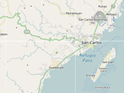
San Carlos & Sipaway Island Map (Orientation + Transport Logic)
What San Carlos & Sipaway Are Known For
San Carlos and Sipaway Island are best known for their mix of working coastal city life, quiet island beaches, and access to upland nature areas around Mount Kanlaon Natural Park.
They operate as a connected system where San Carlos provides transport, markets, and services, while Sipaway Island offers a slower coastal environment through barangays like San Juan, Ermita, and Bagonbon.
This guide explains how the area actually works in practice, using the map to show how city zones, island routes, and surrounding landscapes connect.
What This Map Shows
- San Carlos city layout including Rizal Park, People’s Park, and the public market
- Barangay clusters across coastal and inland areas
- Sipaway Island villages including San Juan, Ermita, and Bagonbon
- Port and wharf access such as Ermita Wharf, Dap-Dap Wharf, and Broce Wharf
- Road networks and transport links from the San Carlos Bus Terminal
- Inland features including Margaha Valley and upland routes toward Mount Kanlaon
How to Use This Map
Use this map to understand how San Carlos and Sipaway Island are structured rather than just where individual places are.
The area works as a connected system where city services, coastal barangays, island access points, and inland routes all link together through a simple but functional network.
San Carlos & Sipaway – How the Area Actually Works
San Carlos appears on most maps as a standard coastal city.
In reality, it operates in layers.
The city core around San Carlos City Hall, the public market, and coastal barangays forms the main hub. From there, movement spreads outward toward wharfs and crossing points, then continues across to Sipaway Island.
Sipaway is not separate in practice. It functions as an extension of the coastline, with daily movement between the city and island through places like Ermita Wharf and Dap-Dap Wharf.
This creates a combined environment where city life, quiet beaches, and rural landscapes exist within one connected system.
What This Map Contains
The map combines locations drawn from mapping data and local structure, including:
- city landmarks such as Rizal Park and San Carlos City People’s Park
- commercial areas like Jose Valmayor Jr. Public Market
- barangays across San Carlos and Sipaway Island
- coastal access points and wharfs including Broce Wharf and Baybay Wharf
- island villages such as San Juan, Ermita, and Bagonbon
- local stays including places like Carmel’s Inn & Restaurant and Dragon Inn
- inland features including Margaha Valley and rivers such as Bago River
Together these locations show how the area functions beyond simple tourist spots.
City Core
The San Carlos city core sits along the coastline and functions as the main hub for movement and daily life.
This includes areas around:
- San Carlos City Hall
- Jose Valmayor Jr. Public Market
- Rizal Park and People’s Park
- transport points like the San Carlos Bus Terminal
This is where supplies, services, and most daily activity are concentrated, and where journeys toward Sipaway Island or inland areas begin.
Barangay Clusters
San Carlos spreads across multiple barangays rather than forming a single dense centre.
Along the coast, barangays connect through roads and access points leading toward the wharfs.
On Sipaway Island, barangays such as San Juan, Ermita, and Bagonbon form smaller, quieter clusters.
These are not tourist zones but working communities, with everyday life continuing alongside visitors.
Coastal, Rural and Upland Zones
Along the coast, San Carlos transitions into fishing areas and access points toward Sipaway Island.
Crossing to Sipaway, the environment changes:
- quieter shoreline
- smaller settlements
- fewer commercial areas
Further inland, the terrain rises toward areas connected to Mount Kanlaon Natural Park, with places like Margaha Valley showing the shift toward rural and upland landscapes.
This contrast between coast, island, and upland defines the area.
Transport Corridors
Movement in San Carlos follows a simple structure.
From the city core:
- roads connect to coastal barangays
- access points lead to wharfs such as Ermita Wharf and Dap-Dap Wharf
- boats cross to Sipaway Island
- island movement continues through basic coastal roads
The San Carlos Bus Terminal links the city to the wider Negros network, while the wharfs connect daily life to the island.
Transport here is functional and local, not built as a tourist system.
What the Map Reveals
Looking at all locations together reveals clear patterns.
The city concentrates along the coastline, with activity focused around markets, parks, and government areas.
Barangays spread outward rather than forming a single centre.
Sipaway Island sits as a direct extension of this system, connected through short crossings rather than distance.
Inland areas quickly transition into quieter rural landscapes, with features like Margaha Valley marking that shift.
Decision Framework
If you want city access and services, stay near the San Carlos coastal core around the market and parks.
If you want quieter beaches, head to Sipaway Island, especially areas like San Juan or Ermita.
If you want local community experience, explore barangay areas beyond the main streets.
If you want nature and space, move inland toward upland areas near Mount Kanlaon.
The map helps align these choices with the actual layout of the area.
Slow-Pacing Reality
San Carlos and Sipaway do not operate at a fast tourist pace.
Movement is steady and local.
Wharfs operate on simple schedules, barangays remain active but not crowded, and Sipaway Island slows down significantly outside peak times.
The island, especially areas like Bagonbon and San Juan, feels noticeably quieter than the city.
How San Carlos & Sipaway Actually Work
San Carlos and Sipaway Island do not function as separate destinations.
They operate as a connected coastal system.
Movement follows a simple pattern:
- activity starts in the city around markets and service areas
- routes move outward toward wharfs like Ermita Wharf
- boats connect to Sipaway Island
- movement continues along the island’s coastal barangays
Because distances are short, timing and access points matter more than distance itself.
Understanding this makes it easier to move between city, coast, and island without treating them as separate places.
The Bigger Picture
Seen through the map, San Carlos and Sipaway Island form a combined system made up of:
- City services and coastal activity
- Barangay networks across land and shoreline
- An offshore island extension through Sipaway
- Rural inland areas leading toward Mount Kanlaon
- Simple transport links connecting everything