
Kabankalan Map (Orientation + Daily-Life Places)
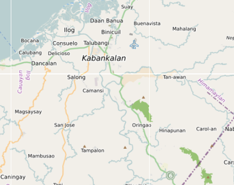
How Kabankalan Actually Works (Map + Daily-Life Guide)
Barangays (90 features)
Kabankalan City has 32 barangays spread across the lowland poblacion and the upland agricultural zones extending toward the mountain interior. The numbered barangays (1–9) are in the poblacion. Named barangays cover the surrounding agricultural and river valley areas. Barangay halls are mapped across the city.
- Poblacion barangays: Barangay 1, 2, 3, 4, 5, 6, 7, 8, 9
- Banga, Banman, Bantayan, Baras Diutay, Binicuil, Bougainvilla
- Camansi, Camingawan, Camugao, Carol-an, Catali
- Daan Banua, Dacongcogon, Hilamonan, Hinapunan, Ilan, Inapoy
- Linao, Locotan, Lowag, Magballo, Mamig, Mindangon
- Oringao, Orong, Pangyasan, Piliopiliohan, Pinaguinpinan
- Sagumayon, Salong, Sampac, San Jose, Tabugon, Tagoc
- Tagukon, Talubangi, Tampalon, Tan-awan, Tapi
- Barangay halls: Bahay Pamahalaan ng Barangay Binicuil, Daan Banua, Magballo, Talubangi, Tabugon, Tampalon
Water & Rivers (218 features)
The most feature-dense layer — 218 features covering the river network, creeks, wetlands, and water bodies across Kabankalan. The named rivers form the main drainage system of the city, running from the mountain interior through the agricultural barangays toward the coast. Most unnamed features are creek geometry and irrigation channels.
- Main rivers: Bayawan River, Binicuil River, Calasa River, Hilabangan River, Ilog River, Magballo River, Mambalod River, Salong River, Suay River, Tablas Valley River, Tinoagan River
- Creeks: Camingawan Creek, Mambalod Creek, Mambalod Gamay Creek, Manangca Creek, Tanawan Creek
- Other: Ilog Bungol, Batutinga, and unnamed streams, water bodies, and wetlands across the barangay system
Markets & Shopping (110 features)
The markets and shopping layer is the most named-feature-dense commercial layer on the map — 103 named establishments covering public markets, malls, department stores, hardware, motorcycle parts, furniture, and the full range of retail that makes Kabankalan a supply centre for the surrounding southern municipalities.
- Main markets: Kabankalan Public Market, Bantayan Public Market, Camingawan Public Market
- Malls: CityMall Kabankalan, Gaisano Grand Mall Kabankalan
- Department stores: Lopue’s, Best Department Store, Unitop, NOVO, Imperial Appliance Plaza, Emcor, Mr. DIY
- Supermarkets: Puregold, I-mart, 7-Eleven
- Motorcycle parts: Gardzkie Motorparts, Keya Motorparts, Lima Motorcycle, Payag Motorcycle, TRANSCYCLE, ZTD Motorcycle Parts, Pablo Auto Supply, Rusco Motors, Rusi Motors, Triumph Hardware, Yamaha 3S Shop, Honda 3S Shop, Motorstar
- Hardware: Golden Key Hardware, HJ Hardware, A&A Bamboo Rattan
- General stores: Aida Store, Cabadan Store, Colon Store, Elvira Store, Emerald Store, Lucky Store, Naldo Store, Super A’s
- Financial services: Cebuana Lhuillier, M. Lhuiller, Taytay Sa Kauswagan Kabankalan Branch
- Other retail: Sunspot, Hashtag, KabJJ Kabankalan, Glory Bazaar, Sky Direct, Julian’s, Bubbles & Blossom, Faciology, Fiesta Lechon
Local Life (76 features)
The local life layer maps the civic and community infrastructure of Kabankalan — universities, government buildings, purok subdivisions within barangays, community centres, and the residential zones that form the daily movement pattern of the city. Central Philippines State University (CPSU) is the main educational anchor.
- Government: City of Kabankalan Government Center, Tabugon Barangay Hall, Tampalon Barangay Hall
- Universities & colleges: Central Philippines State University, ASCO Bible College, Fortress College, Kabankalan Catholic College, Little Way College
- Libraries: ASCO Library, CPSU Library
- Purok subdivisions: Purok 1, 2, 3, 5, 6; Porok Bayhaw Brgy. Camansi, Porok Tuburan Tampalon, Salong Porok Ledesma
- Subdivisions & zones: Isidro Village, Tierra Remedios, Villa Remedios, Bougainvilla, Exevea Memorial Center, FZO 3, FZO 4
- Named areas: Abtao, Alicabog, Badiangay, Bagacay Lower, Bagacay Upper, Ballo, Barracks, Bino, Bugo, Cacao, Calutan, Cogon Adarna, Crossing Bino, Cubay A, Cubay B, Ipil-ipil, Kabukiran, Kalubihan, Liputan, Lupni, Mangga, Overflow, Pacao, Saging, Tuburan, Yuhom
Cafés & Food Areas (40 features)
Food in Kabankalan is concentrated around the town plaza area, Calle Ramos, and the CPSU campus zone. The city has a mix of local restaurants, cafes, fast food chains, and the smaller local eateries serving the market and transport areas. The university presence drives the cafe scene.
- Cafes: Coffee & Talk, Cofioca, Kape Centrale, Sol’s Garden Café, Redbucks, Park ‘On Woods, daily brew
- Local restaurants: Ample Corner, Ayen’s, Balay Tulahan, Bimbimbowls, Calle Ramos, Chicken Ati-Atihan, Chicken Deli, De La Gente Pizza, Golden Plate Pizza, Greenoz, J.M. Sizzler, Kawayan’s, La Familia, Melting Pot, Nanay Mer’s Eatery, Pensiang, Perico, Ricardo’s Cuisine, Rock’O, Rosalino’s Chechen, Shakehouse, Taste & See, Wow Restaurant, bbj, serfino’s asalan
- Fast food chains: Jollibee, McDonald’s, Max’s
- University canteen: CPSU Cafeteria
- Other: Regals Refreshments, Liam Cakes N’ Cupcakes
Services (58 features)
Kabankalan carries the full service range for the southern Negros Occidental corridor — hospitals, banks, pharmacies, fuel stations, and government offices serving not just the city but the surrounding municipalities of Ilog, Cauayan, Hinoba-an, and Sipalay to the south.
- Hospitals: Dr. Gumersindo Garcia Sr. Memorial, Holy Mother of Mercy Hospital, Kabankalan City Hospital, Lorenzo D. Zayco District Hospital
- Health centres: Barangay 7 Health Center, Baranggay 4 Health Center, Maya’s Pharmacy & Medi-Specialty Clinic, San Juan Health Center Brgy Cambugao
- Pharmacies: Mercury Drug, TGP
- Banks: Allied, BDO, BPI, Bank of Commerce, China Bank, CitySavings, DBP, Landbank, PNB, Producers Bank, RCBC
- Fuel stations: Caltex, JETTI, Petron, Phoenix, Seaoil, Shell, Total, VELOX ENERGY
- Government: Kabankalan City Fire Station, Kabankalan City Post Office, Philippine National Police
- Courier & remittance: JRS, Jam, Rigpoint, Cymapsea, Taytay Sa Kauswagan
Culture & Landmarks (23 features)
Churches, heritage sites, and cultural landmarks across Kabankalan. The Kabankalan Cathedral and New-St Francis Xavier Cathedral are the main Catholic structures. Mag-Aso Falls — the most visited natural site near the city — is also in this layer.
- Catholic churches: Kabankalan Cathedral, New-St Francis Xavier Cathedral, San Vicente Ferrer Catholic Church, CPSU Catholic Church, San Juan Church, Good Shepherd Church
- Protestant churches: Baptist Church, Hillside New Life Church, Kabankalan Evangelical Church, South Harvest Church
- Iglesia ni Cristo: Lokal ng Bantayan, Iglesia Ni Cristo
- Other: The Church of Jesus Christ of Latter-day Saints
- Museum: CPSU Museum
- Natural landmark: Mag-Aso Falls — the main waterfall accessible from Kabankalan; the most visited natural site in the area
- Other: Unnamed Artwork, Unnamed Memorial, Unnamed Monument, Unnamed Tower
Nature (9 features)
Natural features and green spaces within and around Kabankalan. The hills and mountains visible from the city mark the edge of the upland terrain that rises toward the island’s interior. Kabankalan Plaza is the main public green space in the town centre.
- Kabankalan Plaza — main public plaza in the town centre
- Amyan Hill — hill feature visible from the lowland city area
- Maronggues Hill — named hill in the upland barangay zone
- Mount Luyang — named mountain in the interior
- Mount Nai-guin — named mountain in the interior
Stay Local (11 features)
Accommodation in Kabankalan is limited by provincial standards — the city is primarily a service and transport hub rather than a destination for overnight stays. Options range from simple pension houses in the town centre to small resorts in the upland barangays.
- Town centre: South Gate Inn, Monbela, Ajp inn, Hans Guest House, Justine’s Guest House, Mansion nina Kuya Ryan
- Upland / resort: Balicaocao Mountain Resort, Zaycoland Resort and Hotel
Transport (10 features)
Kabankalan is the main transport hub for the southern Negros Occidental corridor. The Ceres bus terminal connects the city to Bacolod in the north and to Sipalay and Hinoba-an in the south. The city also has a domestic airport with limited services.
- Ceres Bus Terminal — main departure point for Bacolod northbound and Sipalay southbound services
- Public Terminal — local jeepney and multicab terminal for city and barangay routes
- Kabankalan City Domestic Airport — grass airstrip with limited domestic services
- Tagukon — transport reference point in the northern barangay corridor
- Kabankalan Departures — mapped departure reference
Bridges (17 features)
Named bridges mapped across Kabankalan’s river network — the crossing points on the roads connecting the poblacion to the agricultural and upland barangays. These bridges are the key infrastructure links on the roads leading out of the city centre toward the river valley barangays.
- Batutinga Bridge 3
- Calasa Bridge
- Camugao Hanging Bridge — hanging bridge over the Camugao River
- Catagpu-an Bridge
- Hilabangan Bridge
- Ilog Bridge
- Inawayan Bridge
- Magballo Bridge
- Sagumayon-Villa Progreso Bridge
- Tabla Bridge
Activities (7 features)
Sports and recreation facilities in Kabankalan — mostly barangay-level courts and open areas used for daily exercise and community sport.
- Sports centres and courts — mapped across the city barangays
- Playgrounds — barangay-level recreation areas for children
Kabankalan sits in the southern plains of Negros Occidental, along the highway corridor that connects Himamaylan, Ilog, Cauayan, Sipalay, and Hinoba-an. On a map the city looks compact, but daily life spreads outward through barangay clusters, farming plains, and coastal communities rather than concentrating in a dense downtown. Understanding that layout makes Kabankalan much easier to navigate.
This map brings together barangays, services, markets, transport points, schools, churches, and everyday infrastructure. The goal is not a sightseeing checklist — it is to make the structure of the city easier to understand.
What This Map Contains
Depending on the layer, the map includes barangays and neighbourhood clusters, cafes and small food stalls, grocery stores and supply shops, pharmacies and medical services, schools, churches, and public buildings, fuel stations and roadside services, markets and commercial streets, and rural road connections to surrounding towns. Together these show the practical structure of everyday life in Kabankalan.
The City Core
Daily activity centres around the commercial streets near Kabankalan Public Market, the City Hall area, and the surrounding neighbourhoods of Barangay 4 and Barangay 5. This is where residents handle daily errands, food shopping, and basic services — the public market, grocery and supply stores, pharmacies, banks, bakeries, and small eateries are all concentrated here. The market is best visited early morning, errands mid-morning, and the area becomes active again in late afternoon when the heat drops.
Barangay Clusters
Kabankalan spreads through a network of barangays rather than a dense urban centre. Residential areas extend outward through Hilamonan, Orong, Talubangi, Magballo, Binicuil, and Daan Banwa. Within these barangays the map shows sari-sari stores, local schools and churches, basketball courts and community halls, and roadside food stalls. Movement between barangays happens along smaller connecting roads rather than the main highway.
The Coastal Edge
West of Kabankalan the landscape gradually approaches the Sulu Sea coastline. Along this coastal belt the map covers fishing communities and shoreline barangays connecting the city with Ilog and Cauayan. These areas revolve around small fishing boats and landing points, coastal village markets, seafood cooking, and local transport between coastal barangays. The coast here is not built around resorts — it reflects everyday coastal life and working fishing communities.
The Agricultural Plains
Outside the town centre the map shows a landscape dominated by sugarcane plantations, rice paddies, irrigation canals, and farm roads connecting rural barangays. This farming landscape shapes the rhythm of the region. Most of the roads around Kabankalan exist to connect farms, villages, and markets rather than tourist sites.
Transport Corridors
Kabankalan lies along the provincial highway linking much of southern Negros — connecting Himamaylan to the north, Ilog and Cauayan nearby, Sipalay further south, and Hinoba-an near the southern end of the island. An important inland route also leads toward Mabinay in Negros Oriental, linking the west coast with the eastern side of the island through the interior. Because of these routes Kabankalan functions as a regional movement hub rather than a tourist destination.
How It Actually Works
Commercial activity clusters around the public market. Residential life spreads through multiple barangays. Farmland surrounds the city on nearly all sides. Fishing communities appear along the western coastline. Provincial roads connect the city to surrounding towns. Kabankalan is not structured as a single compact city — it functions as a network of barangays connected by farming, markets, and road corridors.
The place rewards early market visits, morning errands before the heat, afternoon countryside drives, and evening food stalls near the town centre. Heat, agriculture, and local routines shape how people move here. Tightly packed itineraries, long midday walks, and assumptions that short distances are quick to travel do not fit how the city actually operates.