Valencia Map (Upland Town + Waterfalls + Forest Access Guide)
How Valencia Actually Works (Map + Upland Guide)
Valencia sits only a few kilometres inland from Dumaguete, but it operates in a completely different rhythm.
Where Dumaguete is coastal and dense, Valencia spreads across foothills at the base of the Cuernos de Negros mountain range.
The town functions less like a city grid and more like a network of barangays, waterfall routes, forest roads, and small café clusters.
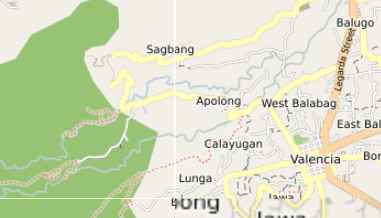
This map highlights the places that shape how Valencia actually works — from the Valencia Public Market and town plaza, to the Pulangbato Falls road, the Casaroro Falls trailhead, and the Forest Camp and Mount Talinis access routes.
Instead of listing attractions, the map shows the practical anchors that define movement through the town.
What This Map Contains
The Valencia map combines locations drawn from open mapping data and local observation.
These include:
- Valencia Public Market and town center services
- cafés and bakeries such as Valencia Bakery and roadside cafés along the Dumaguete–Valencia road
- nature sites including Pulangbato Falls and Casaroro Falls
- forest and mountain access routes toward Mount Talinis
- barangays such as Balili, Palinpinon, and Liptong
- small neighbourhood shops and roadside eateries
- springs, rivers, and upland nature areas
Together these locations form a practical picture of how Valencia functions as Dumaguete’s upland counterpart.
The Town Center: Valencia’s Everyday Core
The heart of Valencia sits around the Valencia Public Market, municipal hall, and town plaza.
This is where daily life concentrates.
You’ll find:
- produce vendors and market stalls
- bakeries and small eateries
- hardware stores and supply shops
- tricycle transport stands connecting to Dumaguete
Unlike Dumaguete’s coastal strip, Valencia’s center is designed around local routines rather than visitors.
Most trips into the town start or pass through this area.
The Café Corridor: The Road from Dumaguete
The main road connecting Dumaguete to Valencia forms a small café corridor.
Along this route you’ll find relaxed places that attract both locals and longer-stay visitors.
These cafés tend to sit slightly uphill, offering:
- cooler temperatures than the coast
- mountain views toward Mount Talinis
- a slower, quieter rhythm than Dumaguete
For many people living in the area, this road becomes the natural social corridor between city and upland town.
The Waterfall Routes: Valencia’s Natural Anchors
Valencia’s most recognised natural sites sit further inland along mountain roads.
Key locations include:
- Pulangbato Falls, known for its reddish rock formations
- Casaroro Falls, a tall waterfall reached by a long staircase descent
- smaller rivers and springs scattered through nearby barangays
These locations shape much of Valencia’s visitor movement.
However, most require:
- motorbike or tricycle transport
- short hikes or stair descents
- awareness of weather conditions after rainfall
Forest Camp and Mount Talinis Access
Beyond the town center, Valencia becomes the gateway to the forests of Mount Talinis.
Important access points include:
- Forest Camp Nature Resort
- mountain trailheads used by trekkers
- geothermal areas around Palinpinon
This zone attracts visitors interested in hiking, forest walks, and cooler upland climates.
Barangays and the Upland Spread
Valencia spreads outward through barangays rather than forming a dense center.
Key areas include:
- Balili
- Palinpinon
- Liptong
These areas contain small shops, chapels, farms, and roadside eateries, forming the real everyday structure of the town.
What the Map Reveals
- Valencia spreads outward along hillside roads rather than forming a tight grid
- cafés cluster along the Dumaguete access road
- waterfalls anchor inland movement
- barangays form the town’s social structure
- Dumaguete remains the main service city nearby
Valencia is not simply a suburb of Dumaguete.
It is a separate upland system connected by a short corridor.
Using the Valencia Map
Start by orienting yourself around:
- Valencia Public Market and town plaza
- the Dumaguete–Valencia road corridor
- waterfall routes toward Pulangbato and Casaroro
Then explore outward toward cafés, forest access points, and barangay communities.
Practical Anchors on the Map
- Town center → Valencia Public Market
- Nature access → Pulangbato and Casaroro Falls
- Mountain access → Forest Camp and Talinis routes
- Café stops → roadside cafés along the Dumaguete road
Decision Framework
- Cooler air → Valencia foothills
- Waterfalls → Pulangbato or Casaroro routes
- Café time → Dumaguete–Valencia road
- Forest trekking → Mount Talinis access
- Urban services → Dumaguete
Valencia works best as a slow base rather than a checklist stop.
The Bigger Picture
- town center services
- café corridor
- waterfall routes
- forest road access
- barangay foothills
Understanding these layers turns Valencia from a quick stop into a place that makes sense.