Dumaguete Map (Orientation + Daily-Life Guide)
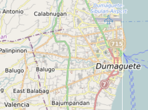
How Dumaguete Actually Works (Map + Daily-Life Guide)
Dumaguete looks compact on most maps. And in many ways, it is.
But daily life in the city doesn’t operate as one smooth, walkable whole. It works in layers — the coastal spine, the university belt, the downtown grid, the market core, the institutional areas, and the inland transition toward Valencia.
This interactive map brings together more than a thousand mapped places across the Dumaguete area, including everyday services, cafés, neighbourhood anchors, transport points, institutions, and practical infrastructure.
Instead of focusing only on attractions, the map highlights the locations that shape how the city actually works.
The goal is not to create a checklist of places to visit.
It is to make the structure of the city easier to understand.
What This Map Contains
The Dumaguete map combines several types of locations drawn from open mapping data and local observation.
Depending on the layer, the map includes:
• cafés and small eateries
• grocery and supply shops
• pharmacies and medical services
• fuel stations and parking areas
• markets and shopping clusters
• barangays and neighbourhood markers
• transport points including port, airport, and bus terminals
• landmarks and public institutions
• coastal access points and dive-route connections
Together these form a practical reference for understanding how Dumaguete functions day to day.
The map works best as an orientation tool rather than a list of attractions.
The Coastal Spine: Visible Dumaguete
Rizal Boulevard, the Dumaguete Port Area, and the Cathedral–Quezon Park area form the city’s most visible face.
This stretch works best:
• early morning walks
• sunset strolls
• short evening visits
Nearby landmarks include:
• St. Catherine of Alexandria Cathedral
• Quezon Park
• Silliman Hall
• Silliman University Anthropology Museum
The waterfront is scenic, but most everyday life sits a few blocks inland.
Suits:
• first-time visitors
• short stays
• people without motorbikes
Limitations:
• strong midday heat
• limited shade
• higher accommodation prices near the Boulevard
The University Belt: Walkable and Balanced
The Silliman University area forms one of Dumaguete’s most balanced neighbourhoods.
This zone blends:
• student housing
• cafés and casual restaurants
• budget accommodation
• small shops and services
It is quieter than the Boulevard at night but still lively during the day.
For many visitors, this area offers the best balance between:
• walkability
• food options
• everyday services
Suits:
• remote workers
• longer stays
• budget travellers
• people wanting activity without heavy nightlife
The Central Grid: Practical Daily Life
Moving inland toward the downtown grid reveals the most practical side of Dumaguete.
Around Perdices Street, Lee Super Plaza, and surrounding streets the map shows a dense cluster of everyday services.
These include:
• grocery shops
• pharmacies
• ATM areas
• small eateries
• supply stores
This area isn’t scenic, but it is where errands and daily life happen.
Walkability remains reasonable, though traffic and heat increase during midday.
The Market District: Dense and Essential
The Dumaguete Public Market and surrounding streets form the city’s most concentrated commercial area.
Here you’ll find:
• fresh produce
• wholesale goods
• budget supplies
• transport connections
This area is useful but intense.
Expect:
• congestion
• narrow walkways
• limited parking
Best visited:
• early morning
• with a clear purpose
The Medical and Institutional Side
North and inland from the city center lies a quieter institutional zone around Daro.
Key locations include:
• Negros Oriental Provincial Hospital
• Silliman Medical Center
• residential neighbourhoods
Compared with the waterfront, this part of the city has:
• less tourism
• more long-term housing
• a calmer pace
It suits:
• longer stays
• families
• people needing medical access
Transport Edges and Gateways
The outer edges of the city define how people move in and out of Dumaguete.
Important transport anchors include:
• Dumaguete Port Area
• Sibulan Airport corridor
• Ceres Bus Terminal northbound and southbound
These locations shape:
• day trips
• inter-island travel
• provincial movement
For short stays, being near at least one transport anchor can reduce friction.
Southbound Marine Access
Heading south from Dumaguete, the map begins to transition from urban infrastructure to marine travel access.
Key connectors include:
• Dauin dive coast access
• Apo Island ferry booking points
This corridor suits:
• dive travellers
• marine-focused itineraries
It is not designed for car-free urban exploration.
Transport planning matters here.
The Inland Shift: Valencia and Upland Access
Moving inland from Dumaguete brings a noticeable change.
Valencia sits at a slightly higher elevation and offers:
• cooler air
• greener surroundings
• quieter neighbourhoods
Key access points include routes toward:
• Pulangbato Falls
• mountain trekking areas
• upland viewpoints
Valencia works best as:
• a second-phase stay
• a quieter residential alternative
• a base for nature trips
It functions as a separate upland system rather than an extension of downtown.
What the Map Reveals
When all locations are displayed together, several patterns become clear.
• Coastal activity concentrates in a narrow strip
• Everyday services cluster slightly inland
• The market core forms the city’s densest commercial zone
• Medical and residential areas sit toward the northwest
• Dive access pulls movement south
• Transport gateways define the city’s edges
• Valencia forms a separate upland layer
Dumaguete is compact, but it is not one continuous experience.
It is layered.
Understanding those layers prevents over-planning and unnecessary travel friction.
Using the Dumaguete Map
Because the map includes a large number of locations, it works best when used selectively.
Start by orienting yourself around:
• the waterfront
• the downtown grid
• major transport points
Then use the map to identify practical anchors such as:
• cafés and food stops
• pharmacies and groceries
• transport connections
• neighbourhood areas
Viewing the map in full screen mode makes the layout easier to understand.
Practical Anchors on the Map
Certain clusters tend to matter most during a stay.
Groceries and supplies
Downtown around Lee Super Plaza.
Medical services
Daro area near the provincial hospital.
Transport gateways
Port, airport corridor, and bus terminals.
Cafés and student life
Silliman University area.
These anchors shape how people move through the city.
Decision Framework
If you want:
Walkable activity → stay near Boulevard or university belt
Practical access → central grid
Local immersion → market district visits
Dive focus → south coast planning
Cooler air → Valencia
Medical proximity → Daro area
Quick onward travel → near port or bus terminals
Slow-Pacing Reality
Dumaguete rewards slower rhythms.
Best patterns include:
• morning coastal walks
• early market visits
• midday shade breaks
• afternoon inland drives
It does not reward:
• attraction stacking
• long midday walks in heat
• assuming short distances always mean easy travel
Heat and transport shape the experience more than distance alone.
Who Dumaguete Suits
Best for:
• compact city exploration
• dive-focused travel
• budget-friendly stays
• student-aligned lifestyles
Less suited for:
• resort-style beach vacations
• fast multi-city itineraries
• luxury coastal tourism
The Bigger Picture
This map shows Dumaguete not as a checklist destination but as a compact working city.
Coastal spine.
University belt.
Market core.
Transport edges.
Southern marine corridor.
Upland second zone.
Understanding those layers turns a confusing arrival into a manageable stay.