Apo Island – South East Coast Map Dauin Dive Site
Apo Island – Diving, Snorkeling & Village Layout Explained
Apo Island is best known for its marine sanctuary, shore-access snorkeling with turtles, and reef dive sites that sit directly beside a working village.
It operates as a compact island system where village life, reef access, and tourism activity all share the same coastline rather than being separated into zones.
This guide explains how that system works in practice, using the map to show how these layers connect.
Dauin Dive Site & Village Coast Guide
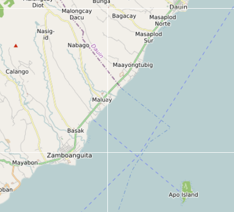
Apo Island sits about seven kilometres off the coast of Dauin in Negros Oriental and is widely known as one of the Philippines’ earliest and most successful marine sanctuary islands.
On most travel maps it appears as a small green dot surrounded by coral reef.
In reality the island works in layers — the village shoreline where boats arrive, the marine sanctuary zone where most snorkeling takes place, the deeper dive sites along the outer reef edge, and the steeper volcanic slopes that rise behind the settlement.
This interactive map focuses on the south-east coast of Apo Island, the area where daily life, tourism activity, and reef access intersect.
Instead of listing only dive sites, the map highlights the features that explain how the island actually functions: village neighbourhoods, homestays, reef zones, viewpoints, and the boat routes connecting Apo Island to the mainland.
The goal is not to create a checklist of attractions.
It is to make the structure of the island easier to understand.
What This Map Contains
The Apo Island map combines several types of locations drawn from open mapping data and local observation.
Depending on the layer, the map includes:
- village neighbourhood areas
- homestays and small guesthouses
- dive sites and reef zones
- marine sanctuary areas
- viewpoints and hilltop landmarks
- small cafés and island eateries
- shoreline access points
- boat landing beaches
- mainland travel connections toward Dauin
Together these locations reveal the practical layout of the island rather than only its tourism highlights.
The map works best as an orientation tool for understanding how Apo Island functions day to day.
City Core
Although Apo Island is small, the village shoreline on the south-east coast works as the island’s core.
This area contains most of the island’s homes and community spaces, including:
- the main Apo Island village settlement
- the Chapel of Saint Vincent Ferrer
- the Tourist Information Center
- small sari-sari stores and supply points
- local boat landing beaches
This shoreline is where boats from Malatapay and Dauin arrive, and where most snorkeling tours begin.
Unlike resort islands, the settlement remains a working fishing village, and tourism activities operate within that local framework.
For visitors, this area functions as the island’s entry point and social center.
Barangay Clusters
Apo Island is administratively part of Barangay Apo in the municipality of Dauin.
Within the island itself the map shows several neighbourhood clusters that have developed over time:
- Katipanan
- Cogon
- Baluarte
- Kan-Uran
These are not tourism districts but local neighbourhood areas where families live and where much of the island’s everyday life takes place.
Paths connect these clusters across the slopes above the shoreline.
Visitors walking beyond the beachfront often discover these small neighbourhood areas quietly woven into the landscape.
Coastal / Rural / Upland Zones
Moving away from the shoreline reveals how dramatically the island’s landscape changes.
Behind the village the land rises steeply into volcanic hills covered with vegetation and coconut trees.
Several viewpoints sit above the settlement, including:
- Old Apo Lighthouse
- Kan-Uran View Deck
- hillside viewpoints overlooking the reef
From these higher areas the island’s layout becomes clear.
The settlement sits on a narrow coastal strip, with the reef extending outward into deeper water and the hills rising sharply behind it.
This contrast between reef and hillside is one of the defining characteristics of Apo Island.
Transport Corridors
Although the island itself has no vehicles, it sits within a clear transport network connecting it to mainland Negros.
Most visitors reach Apo Island through Malatapay Port in Dauin, which serves as the primary jump-off point for boats.
From there, boats cross the channel to reach the village shoreline.
This route connects Apo Island to a wider coastal corridor that includes:
- Dauin
- Zamboanguita
- Bacong
- Dumaguete City
These mainland towns provide supplies, accommodation, dive shops, and transport links for visitors heading to the island.
In practice, Apo Island functions as an offshore extension of the Dauin dive coast.
What the Map Reveals
When all mapped locations are viewed together, several patterns emerge.
- The island settlement concentrates along a single shoreline strip
- The marine sanctuary sits directly beside the village
- Dive sites spread around the outer reef edge
- Hills and viewpoints rise steeply behind the settlement
- Boat routes connect the island to Dauin and Malatapay
This layered structure explains why Apo Island feels different from resort-built destinations.
The community, reef, and tourism infrastructure developed together rather than separately.
The village exists beside the sanctuary, not outside it.
Decision Framework
Visitors usually approach Apo Island with different priorities.
Understanding the island’s layout helps shape those choices.
If you want:
- Snorkeling and turtles → Marine Sanctuary zone near the village
- Diving → outer reef sites such as Coconut Point or Mamsa Point
- Village exploration → walk inland paths toward Katipanan and Cogon
- Viewpoints → climb toward the lighthouse or hillside decks
- Quiet evenings → overnight stays in village homestays
The map makes it easier to align these goals with the island’s geography.
Slow-Pacing Reality
Apo Island rewards slower travel patterns.
Most day visitors arrive mid-morning, snorkel the sanctuary, and leave by mid-afternoon.
Once the boats depart, the island becomes noticeably quieter.
The shoreline empties.
Fishing boats return.
The sound of waves replaces the noise of engines.
For visitors staying overnight, the island shifts from a busy dive stop to a calm village environment.
Understanding the map beforehand helps travellers move more naturally through that rhythm.
How Apo Island Actually Works
Apo Island does not operate as a resort destination with separate zones.
The village, marine sanctuary, and tourism activity all exist side by side along a single shoreline.
Movement follows a simple pattern:
- boats arrive at the village coast
- snorkeling happens directly offshore
- diving spreads outward along the reef edge
- paths lead inland toward hillside viewpoints
Because everything is compressed into a small area, distance is less important than timing and activity flow.
Understanding this makes the island easier to navigate and avoids treating it as a list of separate attractions.
The Bigger Picture
Seen through the map, Apo Island is not simply a dive destination.
It is a small island system made of several overlapping layers:
- Village shoreline
- Marine sanctuary reef
- Outer dive sites
- Volcanic uplands
- Mainland transport links
Understanding those layers turns what might look like a tiny island on a map into a place that is easier to navigate and appreciate.
The map does not replace exploration.
It simply makes the island’s structure clearer before you arrive.