
Negros Island Diving Map
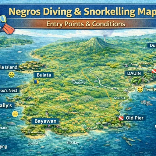
Dive Sites & Sanctuaries
Named dive sites, reef systems, marine sanctuaries, and reef geometry across Negros Island and surrounding waters. The named sites below are the key geographic anchors. The map also contains reef area polygons drawn from OpenStreetMap data covering the reef geometry of the full coastline.
- East coast — Dauin zone: Dauin Marine Reserve and Sanctuary — the primary protected dive area on the east coast; multiple shore-access entry points along the Dauin barangay strip; muck diving along the sandy slopes between coral heads
- East coast — named reefs: Coconut Point, Cogon, Kan Uran, Katipanan, La Playa Reef, Largahan, Mamsa Point, Macahulom Reef, Osmol Reef, Panal Reef, Peeble Reef, Rock Point East, Rock Point West, Tabon Reef
- Apo Island: Chapel, Coconut Point, Cars Dive — reef systems around Apo Island sitting within the Apo Island Protected Landscape and Seascape; sanctuary zones enforced by the island’s marine management committee
- Siquijor: Tulapos Marine Sanctuary — protected sanctuary on Siquijor’s north coast; Twin Peaks, Baluarte — named dive sites around the island
- West coast — Sipalay zone: Andres Reef, Bonifacio Reef, Convention Reef, Guadalupe Reef, Hillary’s Reef, Manta Reef, North Wall, Tanguigue Reef, Wilson’s Reef — reef systems in and around Campomanes Bay
- North coast: Sagay Marine Reserve — large protected area off the north coast of Negros Occidental; Carbin Reef — offshore reef within the reserve boundary; Manjuyod Reef — reef near the Manjuyod sandbar area
- Other named sites: Bonifacio Reef, San Antonio Reef, Baluarte, Local Dive Sites (OSM mapped entry points along the coast)
Dive Operators & Stays
Dive operators and dive-connected accommodation across Negros Island and Siquijor. The east coast Dauin–Dumaguete corridor has the highest density of operators. Most serve their own guests primarily. Independent divers can arrange trips directly.
- Dauin – Dumaguete corridor: Aqua-Landia Dive Resort, Azure Dive & Yoga Resort, Beach Cafe & Dream Diving Resort, Bongo Bongo Divers, Ex Bahura Dive Resort, Flora’s Dive & Resort, Harold’s Dive Center, Kawayan Holiday Divers, Kiwi Dive Resort, Mystic Divers, Oceanlife Explorers Resort Dive and Research Center, People Dive Resort, Sea Pearl Divers, Wellbeach Dive Resort
- Dumaguete based: Dumaguete Divers — city-based operator running trips to Dauin and Apo Island
- West coast — Sipalay: AivyMaes Divers Paradise Resort, Nabulao Dive and Beach Resort
- Siquijor: Siquijor Divers — operator based on Siquijor
- Other operators: Dive Point DC, Dive Point Siquijor, Dive-Society, DiveWorks, Last Frontier Dive, Paul’s Dive Shop — mapped at their base locations
Boat Access & Ports
The full coastal infrastructure of Negros Island — ports, piers, wharves, ferry terminals, and access points used for dive boat departures, inter-island movement, and coastal transport. The map includes all OSM-tagged coastal infrastructure, which covers working fishing piers and commercial ports alongside dive-relevant departure points.
- Main dive departure points: Malatapay — primary departure point for Apo Island from Zamboanguita; Dauin — shore access and banca departures along the barangay strip; Dumaguete Port — ferry connections to Siquijor and Cebu
- Siquijor arrivals: Larena — main port on Siquijor; Larena Passenger Terminal Building; Lazi — secondary port
- West coast: Basak Port — Sipalay area; Manta-angan Pier and Ferry Terminal — Cauayan coast; Nabulao and bay access points
- North coast: Cadiz City Pier, Cadiz City Port, Cadiz Viejo Port, Old Sagay Port, Escalante Port, Toboso Port, Tambisan Port, Port of Calatrava
- Bacolod: Bacolod Port, Banago Sea Port — main Negros Occidental inter-island ports; 2GO ferry services; Old Silay Wharf
- Other named wharves: Aguisan Pier, Broce Wharf, Butoy Wharf, Canibol Wharf, Capiñahan Wharf, Dap-Dap Wharf, Ermita Wharf, Papa’s Wharf, Pitogo Wharf, Pulupandan, Tampi Port, Tampi Wharf, Guihulngan Bulado Port, Sibulan, Siaton
- Kayak access: Kayak Pier, Laka Balanan Kayak Pier — marked for non-motorised water access
Islands & Offshore Areas
The main offshore dive destinations connected to Negros Island by boat. Apo Island is the primary offshore dive destination — a small island 7 kilometres off the Dauin coast with a marine sanctuary covering most of its surrounding reef. Siquijor, though a separate province, is reachable from Dumaguete and sits within the dive network of the region.
- Apo Island — 7km offshore from Dauin; boats depart from Malatapay (Zamboanguita) and Dauin proper; the island’s community-managed marine sanctuary has been active since the 1980s; reef systems on all sides of the island; sanctuary zone requires boat escort and sanctuary fee
- Lakawon Island — island off the north coast of Negros Occidental, near Cadiz; beach and reef access; different character from the east coast dive zone
- Manjuyod Sandbar — tidal sandbar in Bais Bay; seasonal; not a dive site but part of the coastal map geography
- Negros Shoal — offshore shoal area mapped in the surrounding waters
- Siquijor — island province reachable from Dumaguete Port by fast ferry; Tulapos Marine Sanctuary on the north coast; dive operators based in San Juan and other municipalities around the island circuit
Diving on Negros Island is concentrated on the east coast south of Dumaguete, where a continuous strip of shore-access sites, marine sanctuaries, and reef systems runs through the barangays of Dauin and Zamboanguita. Apo Island — 7 kilometres offshore — extends this system into deeper reef territory. The west coast around Sipalay has its own reef network centred on Campomanes Bay, and the north coast holds the Sagay Marine Reserve, one of the larger protected areas in the Visayas.
This map covers the full dive geography of Negros Island Region — named reefs, marine sanctuaries, dive operators, boat departure points, port infrastructure, and the offshore areas connected to the mainland coast.
How the Dive Coast Works
The east coast is the primary dive corridor. The coastal road from Dumaguete south through Bacong, Dauin, and Zamboanguita runs parallel to a shallow sandy slope where coral heads and muck dive sites sit within metres of the shore. Shore diving here does not require a boat — entry is from the beach directly in front of the barangay or resort. The Dauin Marine Reserve and Sanctuary is the formal protected zone covering much of this strip.
The Dauin zone is not a single site. It is a series of entry points along the barangay coastline — each one giving access to a slightly different section of reef and sandy substrate. Named sites include Coconut Point, Cogon, Kan Uran, Katipanan, La Playa Reef, Largahan, Mamsa Point, Macahulom Reef, Osmol Reef, Panal Reef, Peeble Reef, Rock Point East, Rock Point West, and Tabon Reef. Most of these are within a 15-kilometre stretch of coast.
Apo Island operates differently. It is a boat destination, not a shore dive. Boats leave from Malatapay in Zamboanguita — the standard departure point — and from Dauin itself. The crossing takes 30 to 45 minutes depending on conditions. The island’s community-managed marine sanctuary has been operating since the 1980s and is considered a model for reef recovery in the Philippines. Entry into the sanctuary requires a guide from the island and a sanctuary fee collected at the Malatapay landing. Key dive sites around Apo include Chapel, Cars Dive, and Coconut Point — each on a different face of the island.
West Coast Diving
The Sipalay reef system covers Campomanes Bay and the coastal zone around Nabulao and the offshore islands. Named reefs include Andres Reef, Bonifacio Reef, Convention Reef, Guadalupe Reef, Hillary’s Reef, Manta Reef, North Wall, Tanguigue Reef, and Wilson’s Reef. Access is primarily by banca from the resort strip rather than shore entry — the bay configuration means most reef sits offshore rather than immediately adjacent to beach.
Dive operators based in the Sipalay area include AivyMaes Divers Paradise Resort and Nabulao Dive and Beach Resort. This is a smaller, quieter dive zone than Dauin — fewer operators, fewer visiting divers, and sites that require more planning to reach.
Sagay Marine Reserve
The Sagay Marine Reserve sits off the north coast of Negros Occidental, covering a large reef and seagrass system in the Visayan Sea. It is not part of the Dauin or Sipalay dive corridors — reaching it requires a separate trip from Sagay City. Carbin Reef sits within the reserve boundary and is the main named dive site. The reserve also protects nesting areas for sea turtles. Access is arranged through local operators in Sagay and requires a permit.
Siquijor
Siquijor is reachable from Dumaguete Port by fast ferry — a crossing of approximately one hour. It operates as a separate island with its own dive operators and marine sanctuaries. The Tulapos Marine Sanctuary on the north coast is the main protected dive area. Named sites around the island include Baluarte and Twin Peaks. Siquijor Divers is the main operator listed on the map.
Dive Operators
Most dive operators on the east coast are based at resorts along the Dauin barangay strip. They serve their own guests as the primary business model, with independent divers able to arrange dives by contacting operators directly. Operators along the Dauin coast include Aqua-Landia Dive Resort, Azure Dive and Yoga Resort, Beach Cafe and Dream Diving Resort, Bongo Bongo Divers, Ex Bahura Dive Resort, Flora’s Dive and Resort, Harold’s Dive Center, Kawayan Holiday Divers, Kiwi Dive Resort, Mystic Divers, Oceanlife Explorers Resort Dive and Research Center, People Dive Resort, Sea Pearl Divers, and Wellbeach Dive Resort.
Dumaguete Divers operates from the city and runs trips to Dauin and Apo Island — useful for divers staying in Dumaguete rather than on the resort strip.
Boat Access and Port Infrastructure
The map covers the full coastal port and pier infrastructure of Negros Island — all OSM-tagged coastal structures from working fishing piers to commercial ports. For diving, the relevant departure points are Malatapay for Apo Island, the Dauin barangay strip for shore entry and local banca trips, Dumaguete Port for ferries to Siquijor, and the Sipalay coast for west coast reef access.
Larena is the main arrival port on Siquijor, with a passenger terminal building. Lazi has a secondary port on the south coast.
North coast ports — Cadiz, Sagay, Escalante, Toboso, Calatrava, Tambisan — are commercial and fishing ports relevant for access to the Sagay Marine Reserve rather than recreational diving.
Seasonal Conditions
Shore diving along the Dauin coast is possible most of the year. The northeast monsoon (Amihan, November–May) brings calmer seas on the east coast. The southwest monsoon (Habagat, June–October) can affect Apo Island crossings and make some surface conditions choppy. Visibility is generally best during the dry season months from January to May.
The west coast around Sipalay faces the Sulu Sea and is more directly exposed to southwest monsoon conditions. Reef access during June–October depends on conditions that can change day to day.
Related Guides
- The Insider’s Slow Map of Negros — full map series index for Negros Island
- Apo Island & South East Coast Map — detailed map of the Dauin–Apo corridor
- Negros Beaches Map — coastal access points across both provinces
- Slow Travel Map – Negros Island — how transport and movement connects the island